
Geoarchaeology: All the Dirt
What is Geoarchaeology?
Geoarchaeology is the application of earth sciences including primarily geography, geology, and soil science towards establishing context for buried cultural materials. Because geoarchaeology requires a relatively thorough understanding of earth sciences, it is often considered to be a specialty field within archaeology; however, every archaeologist who describes and attempts to interpret the geography of a site and/or aspects of the soil in which they are digging is performing geoarchaeology.
Where does all the dirt come from?
One of the most common questions people have when looking into an archaeologist's excavation pit and seeing items once on the surface but now covered by several feet of soil is, "Where did all that dirt come from?" As it happens this is more or less THE question of geoarchaeology, and the answer often involves several processes occurring simultaneously.
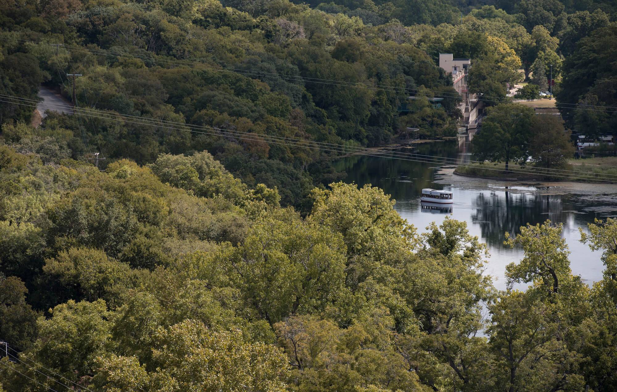
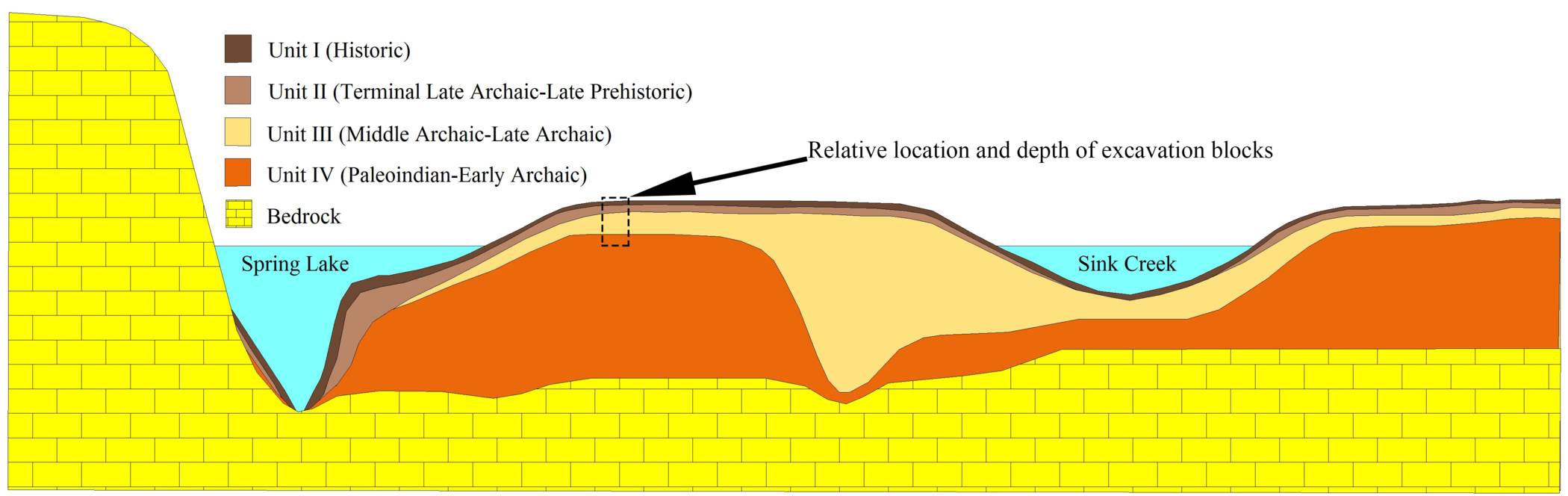
The Spring Lake Peninsula (the area between Sink Creek and Spring Lake) is composed of alluvial sediment (sediment deposited by flowing water). Every time a flood comes down Sink Creek and flows over the peninsula it carries a load of freshly eroded sediment which leaves a film up to several millimeters thick on the ground. Over the past 13,000 years this process has resulted in the accruement of approximately 10 m (30 ft) of sediment in the area of the Spring Lake Data Recovery excavation. The idealized cross section below shows the approximate ages of the sediment of the Spring Lake Peninsula. Notice that the sedimentation rate (speed at which sediment accrues) has decreased over time. The bulk of the peninsula formed between 13,000 and 6,000 years ago with only a fine veneer being left during the last 1,200 years (Nickels and Bousman 2010; Hooge 2013).
Idealized Cross Section of Spring Lake Peninsula Showing Ages of Alluvial Sediments
(from Hooge 2013)
(Not to scale)
Movement of Soil Within the Soil Column
In addition to alluvial sediment brought in by regular floods, cultural materials may by buried or or even moved around under the surface by several biological and meteorological processes.
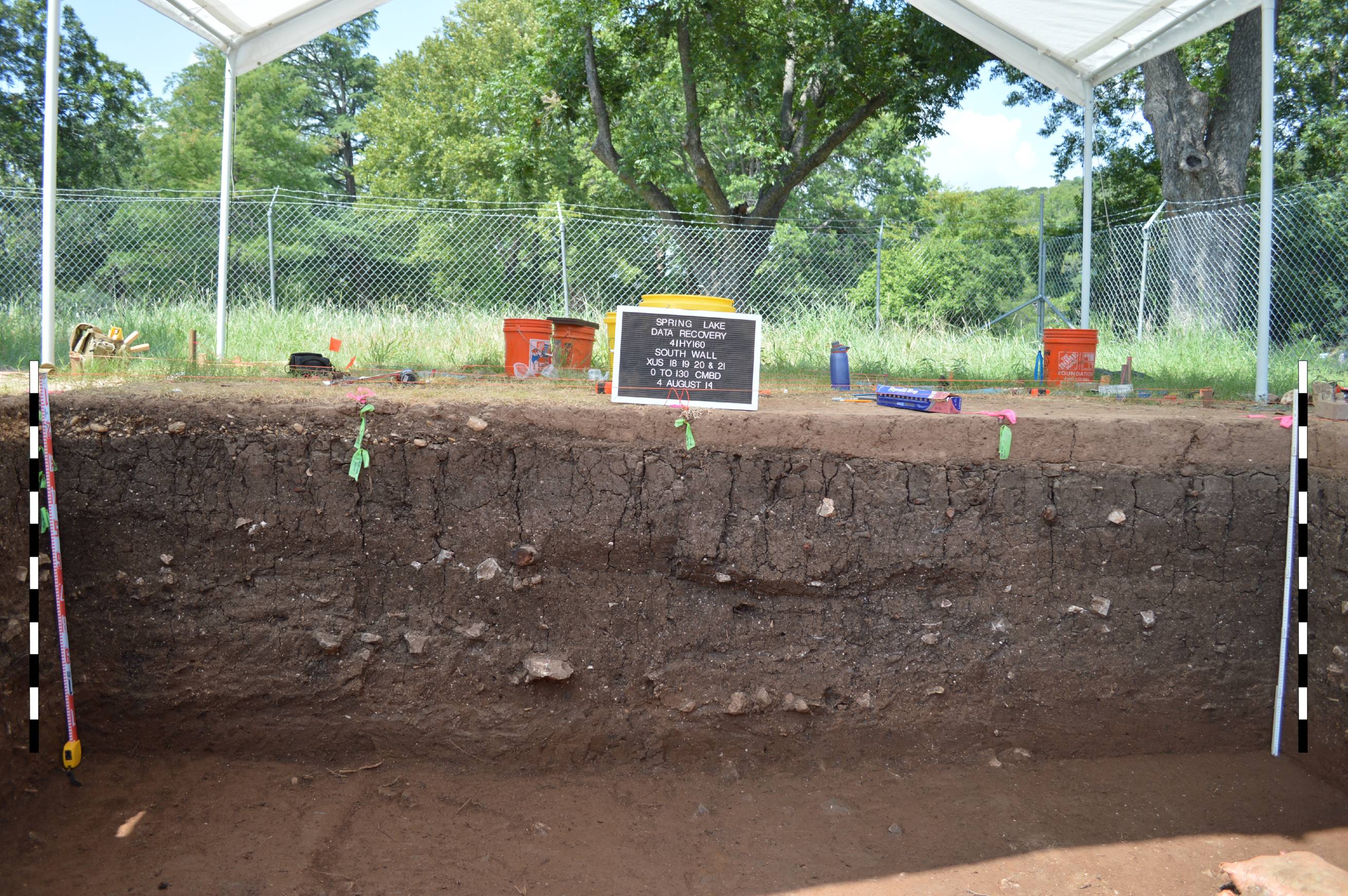
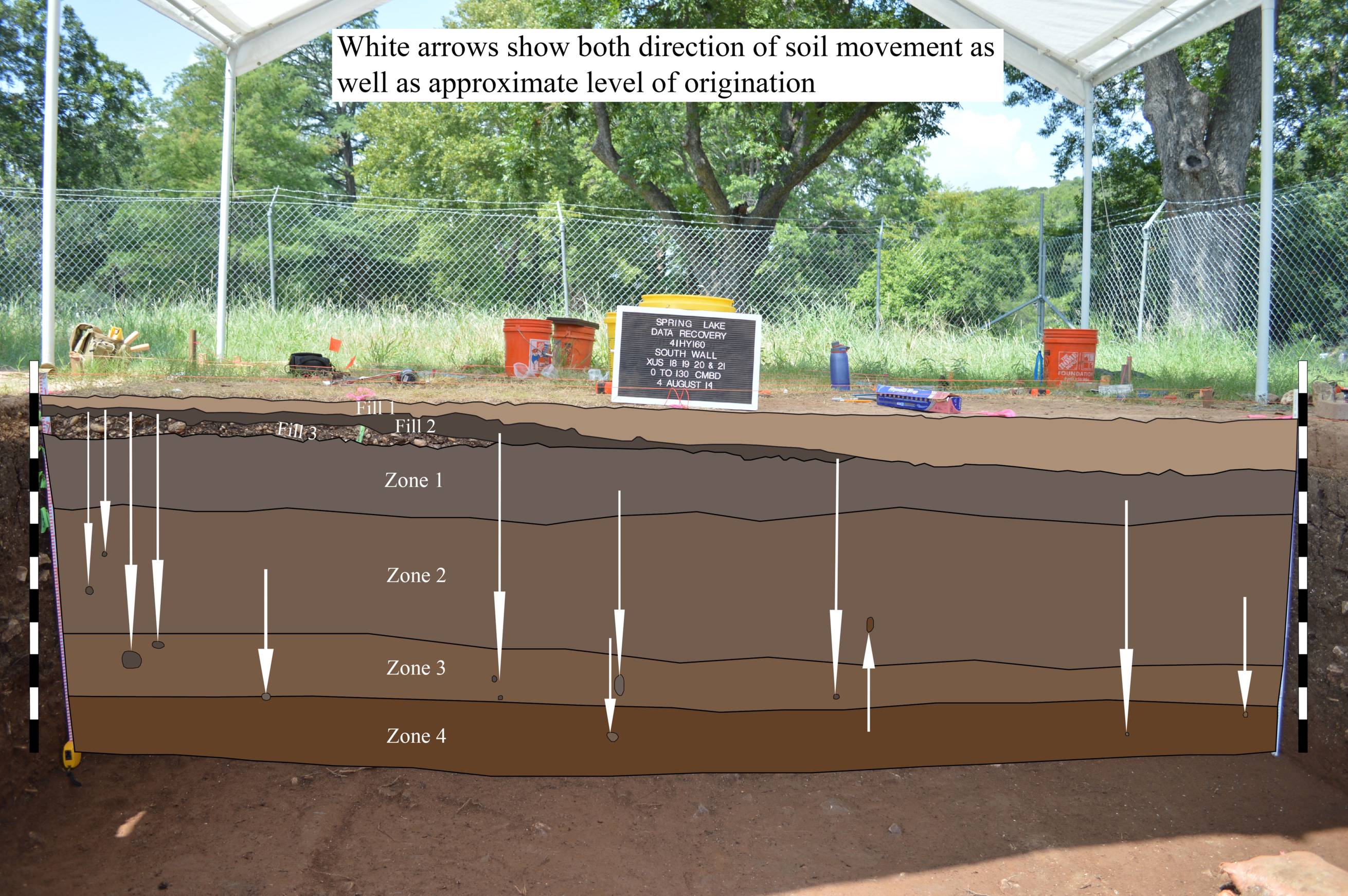
Bioturbation is the movement of soil by plants and animals. The roots of large trees can significantly impact an archaeological site; however, the movement of soil by burrowing animals can be prolific given time. In this way, archaeological sites out of the reach of floods on what are called uplands may be buried under meters of soil. A short list of animals which have impacted the subsurface of the Spring Lake Peninsula include but is not limited to earthworms, grubworms, termites, ants, crayfish, turtles, frogs/toads, gophers, rabbits, mice/rats, and armadillos. The creatures most responsible for the burial of cultural materials are worms, termites, and ants--this may come as a surprise; however, when you imagine the soil making up ant and termite mounds extrapolated over thousands of years it can turn into a large amount of sediment taken from under artifacts and deposited above them. For the movement of artifacts both horizontally and vertically in the ground, burrowing animals like gophers may be to blame. Smaller artifacts like projectile points may be moved up, down, or sideways in the soil column which can lead to mixing of artifacts from different time periods. The series of photos below highlight krotovina or filled-in burrows; the arrows in the final image indicate the vertical movement of the soil filling each burrow based on color. Determining the sideways movement of soil in these krotovina is much more difficult.
In addition to bioturbation, soil and artifacts may also be moved by the soil itself. The soil of the Spring Lake Peninsula is known as a Vertisol, so named for the tendency for vertical movement. Vertisols are dense clays which well when wet and shrink when dry; these soils are known for the large surface cracks which form during droughts. When large cracks are present, smaller artifacts may fall several feet lower than where they were originally deposited. When rains cause the soil to swell the cracks begin to close from the bottom-up; this results in larger artifacts and stones being wedged slightly upward. Farmers have noticed this phenomenon for centuries as plowed fields continue to produce new stones over generations of removing stones from fields. In the first photograph of the series below, cracks can be seen extending from the top of Zone 1 well into the zones below (the upper layers of 'Fill' are non-native soil and gravel imported in recent times).
South Profile Wall of Main Block Showing Krotovina (Filled Burrows)
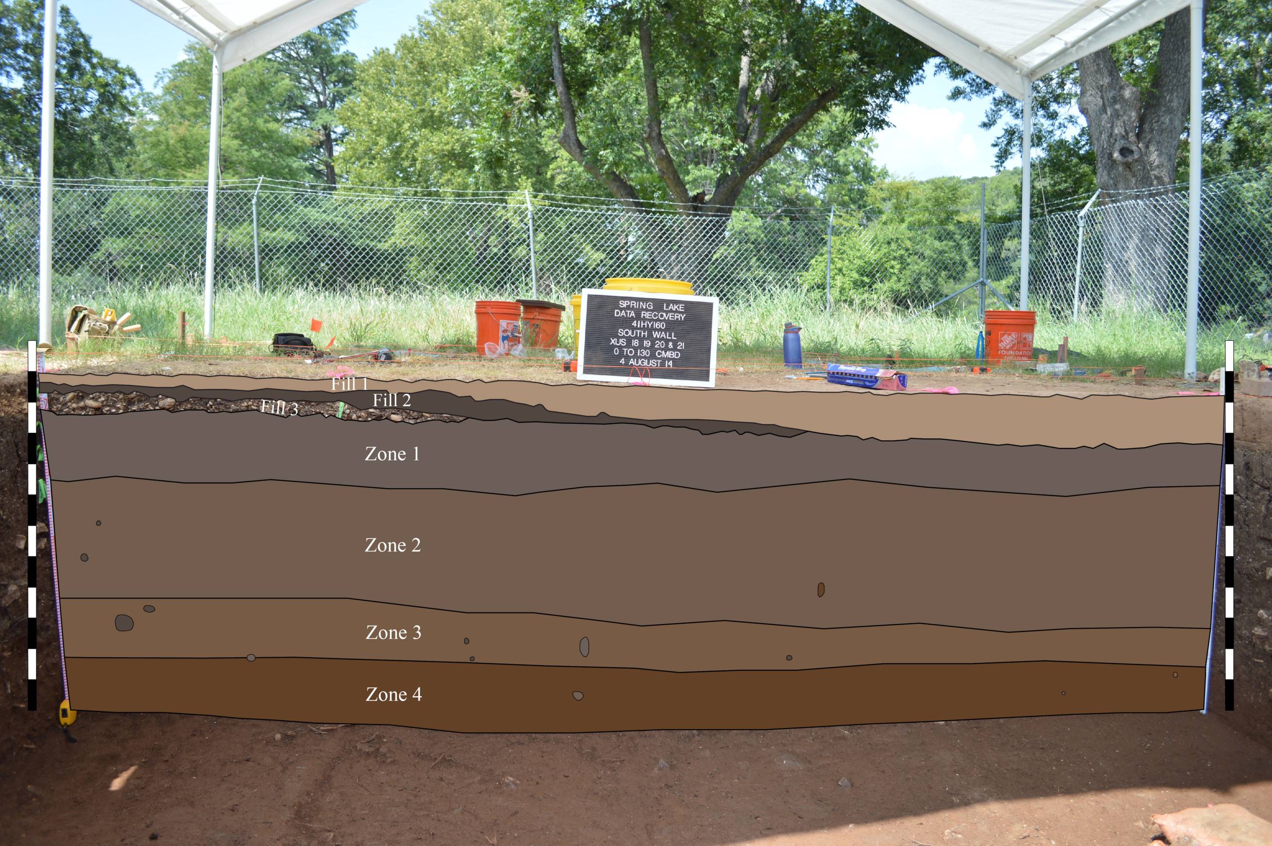
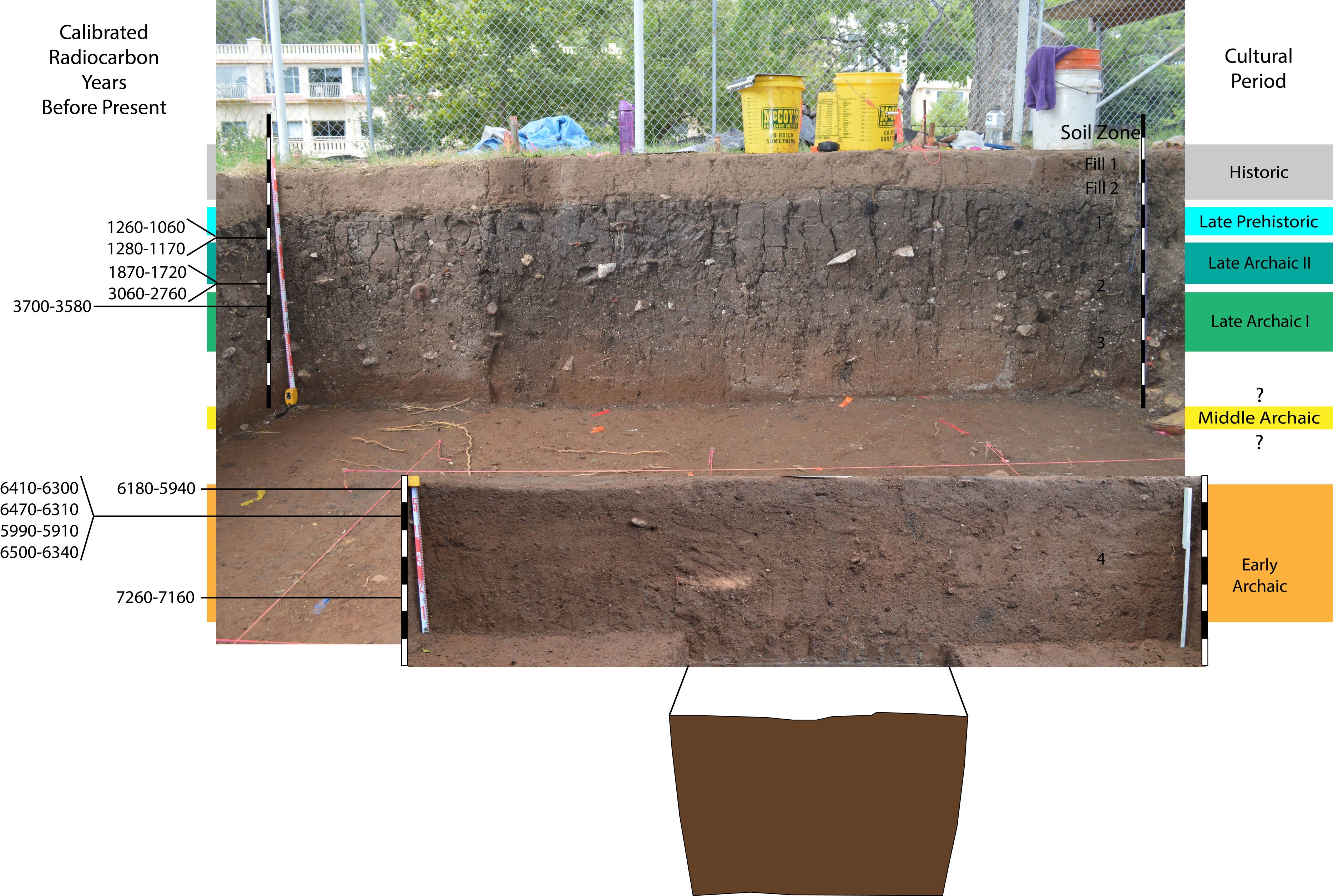
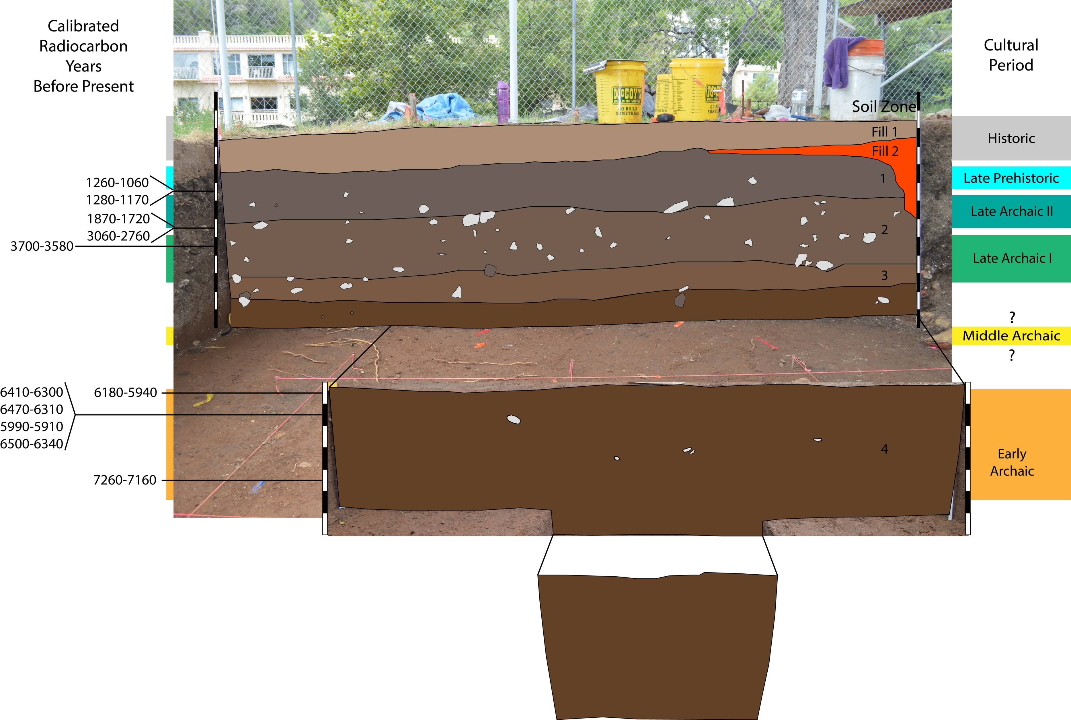
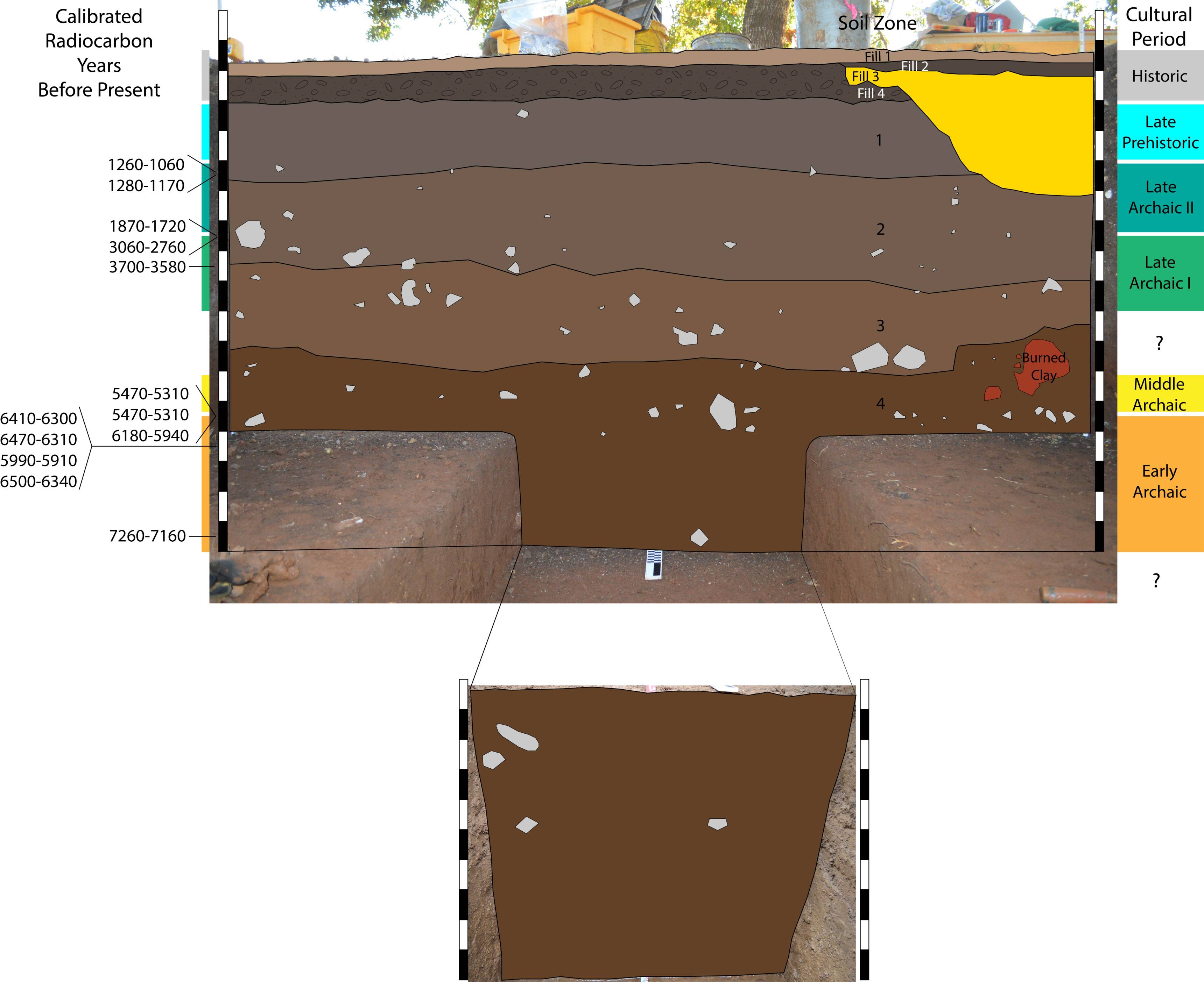
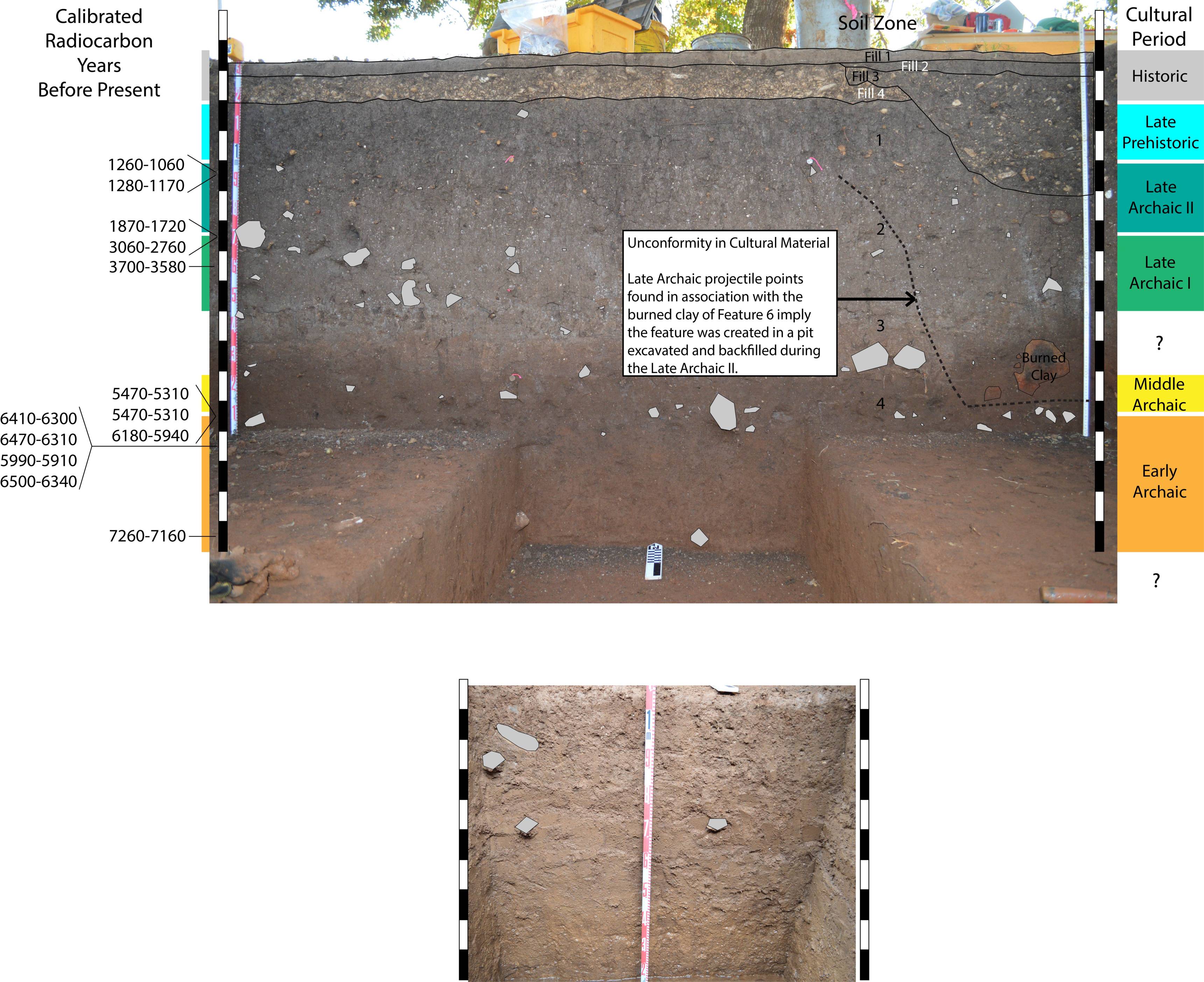
Stratigraphy of Spring Lake Data Recovery Excavation
Both the above and below series of images show a breakdown of the stratigraphy visible in the main excavation block of the Spring Lake Data Recovery.
The uppermost stratum labeled 'Fill 1' is a loamy soil imported by the United States Army Corps of Engineers (USACE) in 2012 as part of the Spring Lake Aquatic Ecosystem Restoration project to promote the growth of a mixture of native grasses. Shortly before Fill 1 was put down, the majority of the Spring Lake Peninsula was bladed to a depth of 10 to 20 cm in order to remove imported sods containing non-native grass seed brought in during the days of the Aquarena Springs amusement park. Although great care was taken to avoid removing native soil (and cultural material with it), the uneven nature of the ground led to a small amount (probably less than 10 cm) of native soil being removed from the west side of the main excavation block. In the series south profile in the series above, the uneven cut of the uppermost soil is visible (note the gravel of Fill 2 which was part of a parking lot used during the early days of the amusement park--It is unclear how much, if any, soil was removed prior to the construction of the parking lot). Because some amount of the top of Zone 1 has been removed, the boundary between Zone 1 and the overlying zones of fill is an unconformity. An unconformity is a gap of time visible in a soil profile; the gap may be the result of a cessation of deposition, a period of erosion (soil removal), or a combination of the two.
In the west profile wall (below), Fill 2 is the backfill of the excavation block of a 2006 Texas State archaeological field school. The field school excavation block was left open for several years resulting in the collapse of the upper parts of the walls and the sloping nature of Fill 2. Fill 2 is contained between two unconformities.
Zones 1 through 4 represent native alluvial soil and the artifacts contained in those zones are in as original context as can be expected after considering the processes of bioturbation and shrink/well mentioned above. The color difference visible between zones is a product of soil diagenesis or soil development due primarily to meteorology; it is important to note the boundaries between Zones 1 through 4 are most likely NOT unconformities. The color changes represent the relatively high amount of organic material in upper soils (darker in color) and the relatively high amount of iron and aluminum oxides in lower soils (redder in color). Soil diagenesis and the difference in constituents within a soil column are the result of time and weather. When rain falls through the atmosphere it picks up a small amount of carbon dioxide becoming mildly acidic. As this acid rain moves through the ground it breaks down organic material and leaches iron, aluminum, and calcium from upper strata; further down the soil column the iron and aluminum is redeposited as oxides (rust, hence the red color) and the calcium as carbonates leading to carbonate nodules (not visible in the photos but present).
West Profile Wall of Main Excavation Block
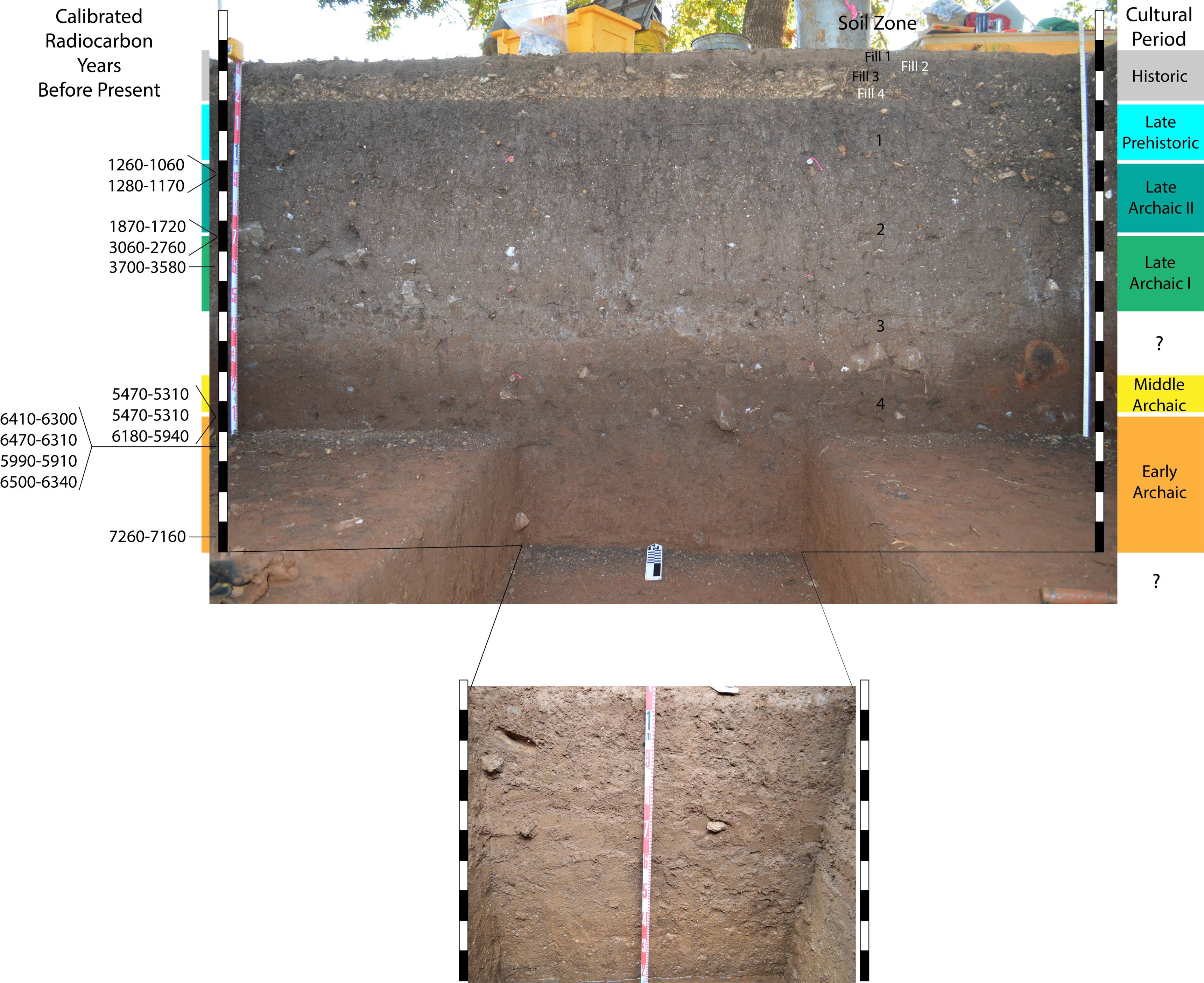
Stratigraphy in the Secondary Excavation Block (pictured below)
For multiple reasons, the north wall of the secondary excavation block (below) is the most interesting profile exposure of the Spring Lake Data Recovery. The wall contains several unconformities, both obvious and more subtle, as well as a somewhat mysterious burned clay feature in the lower right portion. The lower undisturbed portions of the second block (below) are similar to those of the main block (above) with respect to soil zonation, labeled again as Zones 1 through 4. Also similar to the profiles of the main block, the uppermost stratum (Fill 1) is the loam imported by USACE in 2012; however, unlike the main block, a small portion of top soil which was deposited along with imported sod (which USACE attempted to completely remove) is visible as Fill 2. Fill 3 in the secondary block represents a hole which was excavated and backfilled some time before the importation of sod but after that of gravel (Fill 4) for the amusement park parking lot. The backfill of Fill 3 contains a mixture of Fill 4 gravel and Zone 1 soil (including now out of place prehistoric artifacts). Similar to the main block it is difficult to determine whether any soil was removed prior to the deposition of the parking lot gravel.
The most distinctive part of the profile below is Feature 6, visible as the burned clay in the right hand portion of the profile (Feature 6 is described in more detail in the Features section). From a geoarchaeological perspective, Feature 6 is important for what is not visible in the surrounding soil. Analysis of artifacts shows that the soil in and above the Feature 6 is mixed and includes diagnostic projectile points as young as Late Archaic II in the area of the burned clay, implying the feature represents a backfilled void which was created some time in the Late Archaic or later. This would suggest an unconformity exists in the right side of the profile (represented by the dashed line in the third image below). The most important part of the unconformity represented by Feature 6 is that it is invisible relative to diagenetic soil color changes even though it is likely at least 2000 years old. This means that other similar unconformities (pits excavated in prehistory) may exist in past or future excavations which are not easily identifiable by changes in soil characteristics.
North Profile Wall of Secondary Excavation Block
A Generalized Interpretation of Prehistoric Cultural Materials Based on Observations of the Soils of the Spring Lake Peninsula
Within the soil profiles pictured above, there is clearly a higher concentration of burned rock in Middle and Late Archaic soils than in the Early Archaic. This may be due to an intensified use of hot rock cooking during the Middle and Late Archaic; however, it is important to remember that alluvial sediment deposition on the Spring Lake Peninsula was much more rapid during Paleoindian and Early Archaic time. The perceived intensification of the use of hot rock cooking is likely exaggerated by reduced deposition of alluvial sediments during the Middle and Late Archaic (artifacts are separated by more soil during the Early Archaic, less soil during the Middle and Late Archaic).
References Cited
Hooge, Jacob
2013 Underwater Geoarchaeology at Spring Lake, San Marcos, Texas. Unpublished Master's Thesis, Texas State University.
Nickels, David L., and C. Britt Bousman
2010 Archaeological Testing at San Marcos Springs (41HY160) for the Texas Rivers Center, Texas, Hays County, Texas. Archaeological Studies Report no. 13. Center for Archaeological Studies, Texas State University-San Marcos.